Schubert cards. Three-verst maps (with GPS binding). Schubert's Trekhverstovka online
Under Schubert, the work was mainly preparatory in nature. Real, serious work began to be carried out already in the reign of Nicholas I in the middle of the 19th century during the second director of the Military Topographic Depot, Major Pavel Alekseevich Tuchkov. And although the very creation of the map is connected much more with the actions and efforts of Tuchkov, the name “Schubert” still stuck among the people.
The name of Fyodor Fedorovich Schubert was engraved on the commemorative medal “In Commemoration of the 50th Anniversary of the Corps of Military Topographers. 1872". This is a tribute to his hobby, to which he devoted all his free time - numismatics.
The meaning of the "Schubert map" in domestic cartography
The creation of this map has significantly increased the defense capability of our country. All European provinces of Russia, except for Moscow, are marked on it with the image of even small paths, swamps and fords. Separate objects were also indicated: buildings, mills, farms. Ravines, tracts and hills - everything was carefully documented and carefully drawn by cartographers.The first edition of the maps was created from 1846 to 1863. Then reconnaissance was periodically carried out, that is, the addition and refinement of already existing maps.
Currently, the complete atlas of Schubert maps is fully digitized and can be easily found on the Internet. Maps are used by both professional cartographers and historians, as well as travelers and treasure hunters.It was used everywhere right up to 1922, when new aerial survey technologies began to be used, replacing the triangulation method. The accuracy of Schubert's "three-verst" is so great that the cards were used even during the Great Patriotic War. And now they are part of the software of such popular programs as Google earth.
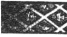
Topographic map of the Moscow province, engraved at the Military Topographic Depot in 1860 on 40 sheets. The scale is 2 versts in the English inch 1:84000.
Of considerable interest is not only the process of creating the map itself, but also the historical period of time that preceded its appearance.
At the end of the 18th century, a radical transformation of the cartographic business in Russia took place, which laid the foundation for an independent military topographic service. Emperor Paul I, shortly after coming to the throne, paid special attention to the lack of good maps in Russia and on November 13, 1796 issued a decree on the transfer of all maps of the General Staff to the disposal of General G.G. Kushelev and about the foundation of His Imperial Majesty the Drawing Room, from which in August 1797 His Majesty's Own Map Depot was created.
This act made it possible to bring order to the publication of maps and made the Map Depot a centralized state archive of cartographic works in order to preserve state and military secrets. At the Depot, a specialized engraving department was established, and in 1800 the Geographical Department was added to it. On February 28, 1812, the Depot of Maps was renamed the Military Topographic Depot with subordination to the War Ministry. Since 1816, the Military Topographic Depot was transferred to the jurisdiction of the General Staff of His Imperial Majesty. In terms of its tasks and organization, the Military Topographic Depot was primarily a cartographic institution. There was no department of topographic surveys, and the necessary number of officers from the army was seconded for the production of maps.
After the end of the war with Napoleon I, much more attention began to be paid to field topographic and geodetic work. Military operations revealed a shortage in maps, and new methods of warfare at that time raised the question of the need for large-scale maps, which, in turn, required a good and fairly dense network of geodetic reference points and accurate topographic surveys. Since 1816, the triangulation of the Vilna province began, which laid the foundation for the development of triangulations in the country, and since 1819, regular topographic surveys were organized on a strict scientific basis. However, the performance of geodetic and topographical work by a small number of quartermaster officers, who, in addition to this, had a lot of other official duties, did not allow starting the process of planned and systematic mapping of the country.
In addition, the costs of maintaining topographic officers seemed too high. Therefore, the question arose of creating a specialized organization for surveying and geodetic work, staffed from persons of non-noble origin. Such an organization, which existed along with the Military Topographic Depot, was formed in 1822 and became known as the Corps of Military Topographers. Its composition was recruited from the most capable pupils of the military orphanage departments - cantonists, sons of soldiers who belonged from birth to the military department in then serf Russia. In order to train the personnel of the Corps of Military Topographers, the Military Topographic School was founded in the same year. The corps of military topographers, established under the General Staff of His Imperial Majesty, became a special organization for carrying out geodetic work, topographic surveys and training a large number of highly qualified topographers.
 The activities of the famous Russian surveyor and cartographer F.F. Schubert, its founder and first director. Fyodor Fedorovich Schubert (1789-1865) was the eldest of the children and the only son of the outstanding astronomer Academician Fyodor Ivanovich Schubert (1758-1825). Until the age of eleven, he was brought up at home, with special attention paid to mathematics and comprehension of languages. During this period, F.F. Schubert read a lot of books from the home library, as well as from the library of the Academy of Sciences, which was in charge of his father. In 1800 F.F. Schubert was assigned to the Peter and Paul School, later renamed the school, without finishing which, in June 1803, at the age of only 14, at the request of his father, he was transferred to the General Staff as a column leader.
Quartermaster General P.K. Sukhtelen, a close acquaintance of Fyodor Fedorovich's father, instilled in the young man, who dreamed of naval service, a great love for topographic and geodetic work. In 1804 F.F. Schubert was sent on two astronomical missions, for the successful execution of the first of them he was promoted to second lieutenant. In the spring of 1805, he took part in a scientific expedition to Siberia led by his father, and in the summer of 1806 he was again busy with astronomical work in Narva and Revel. From October 1806 to February 1819 F.F. Schubert was in the army, taking part in hostilities against the French, Swedes and Turks. During the battle near Preussisch-Eylau in 1807, he was seriously wounded in the chest and left arm and almost died during the attack of Ruschuk. In 1819 F.F. Schubert was appointed head of the 3rd department of the Military Topographic Depot of the General Staff, and from 1820 he became the head of triangulation and topographic survey of the St. Petersburg province and in the same year received the rank of major general.
In 1822 F.F. Schubert develops a draft regulation on the Corps of Military Topographers and soon becomes the first director of the newly established Corps. After 3 years, he was appointed manager, and from 1832 - director (until 1843) of the Military Topographic Depot of the General Staff and the Council of the General Staff Academy. In addition to the positions of F.F. Schubert from 1827 to 1837 was also the head of the Hydrographic Depot of the Main Naval Staff of His Imperial Majesty. Fedor Fedorovich successfully combined the management of these institutions with a number of other equally responsible duties. He supervises extensive trigonometric and topographic work in a number of provinces, organizes the publication of Notes of the Military Topographic Depot and Notes of the Hydrographic Depot; composes and publishes the "Guide for the Calculation of Trigonometric Surveys and the Works of the Military Topographic Depot", which served as the main guide for topographers for several decades. June 20, 1827 F.F. Schubert was elected an honorary member of the St. Petersburg Academy of Sciences, and in 1831 he was promoted to lieutenant general for his distinction in service.
Of considerable importance are the cartographic works of Fedor Fedorovich, especially the ten-verst special map of the Western part of Russia, published by him on 60 sheets, known as the "Schubert Maps", as well as his works devoted to the study of the type and size of the Earth. In 1845 F.F. Schubert becomes general of infantry, and the following year he is appointed director of the Military Scientific Committee of the General Staff, which he led until its abolition in 1859. With such an abundance of responsible positions, F.F. Schubert not only did an excellent job with the duties assigned to him, but also brought a lot of new things to the business of each institution in which he had a chance to work, so his contribution to the development of the domestic military topographic service was very important, and his authority in the scientific world is very huge.
Fyodor Fedorovich devoted his free time from public service to numismatics (in 1857 he published a detailed work on this issue). He was fluent in four languages, perfectly versed in music and painting, was a multifaceted, hardworking and cultured person.
The name of General Schubert is also associated with the creation of a topographic map of the Moscow province, which was engraved at the Military Topographic Depot in 1860. As already indicated above, since 1816, large-scale work began in Russia on laying triangulation and producing topographic surveys based on a strict scientific basis. In 1820, he began his extensive triangulation work and F.F. Schubert. In the period from 1833 to 1839, under his leadership, the triangulation of the Moscow province was carried out, which was fully completed only by 1841. A big drawback of the triangulation work of F.F. Schubert was that he did not pursue the goal of obtaining such a high accuracy, which was inherent in the triangulation of K.I. Tenner and V.Ya. Struve, who at that time were in charge of similar work in Russia. F.F. Schubert attached a purely utilitarian meaning to these works - to provide support only for current topographic surveys, since, being the director of the Military Topographic Depot, he tried to get maps of the largest possible territory of the country. In addition, in his triangulations, F.F. Schubert did not pay due attention to finding the heights of points, which was keenly felt when bringing the lengths of the measured bases to the sea surface. However, these shortcomings of the triangulation work of General Schubert were more than made up for by the high quality of instrumental topographic surveys carried out under his leadership.
The rules for filming have been subject to all sorts of variations over time. The general provisions, true for most cases, were as follows. Trigonometric points were intended as the basis for the breakdown of the geometric network. Only the main objects of the area were filmed instrumentally: big roads, rivers, borders of provinces. For this purpose, the serif method was widely used; in forest spaces it was allowed to use a compass. The main content of the map was depicted with the help of an eye. In the course of the survey, the relief was rendered by contour lines indicating the angular magnitude of the slopes of the terrain, and only the contours of the peaks and thalwegs were instrumentally plotted. The relief was drawn in a chamber setting with strokes in the Leman system.
Topographic instrumental surveys in the Moscow province under the direction of F.F. Schubert were produced in 1838-1839. At this time, only space in the districts of Moscow was filmed. Filming was done on a scale of 200 fathoms to an inch. The requirements that Fedor Fedorovich made to the performers of field work were very high. Suffice it to say that F.F. Schubert strictly forbade the use of a compass, as it could not give the accuracy that could be achieved by filming forest roads using alidade. Subsequently, based on the materials of these surveys, in 1848 a topographic map of the environs of Moscow was issued on 6 sheets on a scale of 1 verst per inch. After quite a long time, the shooting of the Moscow province was continued. In the years 1852-1853 they were produced under the direction of Major Generals Vietinghoff and Rennenkampf and were conducted on a scale of 500 fathoms per inch.
Topographic surveys in the Moscow province were carried out by the Corps of Military Topographers, but we can hardly now accurately identify the direct executors of field work, since their names are not on the map of 1860. But on each of the 40 sheets, we can read the names of the engravers of the Military Topographic Depot below, who prepared this map for publication. In the fragment of this map, presented to your attention, there are four incomplete sheets on each of which 6-7 people worked. Interestingly, among the latter were two free engravers invited from abroad: Yegor Eglov and Heinrich Bornmiller. These artists taught our engravers the best European methods of engraving and took a direct part in the work "for which, in 1864, the Sovereign Emperor Deigned to give them silver medals to wear on the ribbon of the Order of St. Stanislaus, with the inscription "for diligence"".
The original topographic map of the Moscow province of 1860 is a print from an engraving on copper on 40 sheets + a prefabricated sheet, executed in one color. The borders of the province and districts are manually raised with red watercolor paint. The map was compiled in a trapezoidal pseudo-cylindrical multifaceted Muefling projection on a scale of 1:84,000 or, translated into the Russian system of measures, 2 versts per inch. When compiling the map, materials from topographic surveys made in 1852-1853 were used, but it should be noted that the surveys of 1838-1839 were also the basis for creating this map for those sheets that cover the territory of Moscow and its environs. The content of the map is perfect. Of particular interest is the high skill of engravers, thanks to which all elements of the map are perfectly readable. The relief is beautifully engraved, especially the ravine network: the smallest spurs are drawn, which on the current topographic maps of a similar scale can simply be missed. A considerable number of different objects are signed on the map, which makes it possible to use it as the most valuable source of data on toponymy, since many hydronyms are partly lost today - you will not find them on any large-scale topographic map. Even in our time, after almost 140 years, with the help of this document, one can quite confidently navigate the countryside. It is not surprising that in Soviet times the presented map turned out to be classified as secret.
I think there is no need to tell how important cards are in finding coins and treasures. The success of most events depends on their presence or absence. If in the old days a simple desire to get out into the fields was enough, now the situation has changed radically. All more or less well-known tracts, and what's there, even completely lost in the forests and steppes, turned out to be quite thoroughly cleaned for ancient finds.
To keep adding to your collection, or just to enjoy the cop, you have to show more and more remarkable abilities in the field of finding untrodden places. In this case, the most important role is played by the cards of bygone centuries.
Currently, many of them are available to anyone, but as the advertisement says, they are not all equally useful. Yes, this is true, most of them are only suitable for planning trips to broken places.
Below we will describe what cards are, reveal their features and characterize them in terms of usefulness in business.
General Land Survey Plan - PGM (1780-1830)
Topographic materials began to be actively created under Peter I, at which time a large number of geographical atlases of the empire saw the light. During the reign of Catherine II, these works were continued. They, like Peter's, also did not differ in particular accuracy, but, nevertheless, they nevertheless transmitted the necessary and necessary information.
It was under Catherine the Great that the process of mass land surveying began. Its essence was as follows - the entire territory of the country was divided into counties, which, in turn, consisted of the so-called dacha plans, which were nothing more than plots of owners (allots) with confirmed rights to them and established boundaries. All of them received numbers, for their decoding, an additional Economic note was later issued to the survey plans.
These publications can hardly be called maps, because. they are still far from accurate and are more like diagrams-drawings. But still, from them you can get a lot of useful information on the emergence or existence of a particular settlement in those days.
Maps of Mende (1849-1866)
The name of these, and subsequently many other maps, was given by the names of the people who made the greatest contribution to their development and creation. All of them relied on and had the basis of publications created under Catherine and Paul I, it was on these initiatives that the further development of the so necessary was carried out, in primarily military, modern maps.
The new realities of that time revealed the need to create more accurate and detailed maps than the existing Military Road 40-verst publications. Taking the PGM as a basis and conducting large-scale cartographic surveys, military topographers under the leadership of A.I. Mende set about creating new detailed editions.

In total, two varieties of them were released.:
- one-verst, scale 1 inch is equal to 1 verst or 1cm is equal to 420m
- two-verst, scale in 1 inch 2 versts or 1cm 840m.
Such detailed publications appeared in 8 provinces, although surveys of the area were carried out in 21 provinces for 17 years.
provinces
1 and 2 versts - Tver, Vladimir, Ryazan, Penza, Simbirsk and Tambov.
1 verst - Nizhny Novgorod and Penza.
Schubert Maps (1860-1870)
Under the leadership of F.F. Schubert, who headed the Corps of Military Topographers in the early 19th century, a 10-verst map of the Western part of the Russian Empire on 60 sheets was created. But it, like the border 4 and 5 verst, was not very convenient, so soon work began on another.
A new map - three-versts was created first under the leadership of Major General P. A. Tuchkov (until 1851), and then work continued with the participation of Schubert. The period of its creation covers the second half of the 19th century, starting from 1846.
The scale is 3 versts in 1 inch or 1260 m in 1 cm.

The main part of the work was done before 1863 (435 sheets), further work was not suspended (in 1886 - 508 sheets), but basically it was reduced to supplementing and clarifying previous editions.
They turned out to contain cartographic material for all the provinces of the European part of the empire (with the exception of Moscow) and part of the adjacent territories (Ukraine, Belarus, Moldova and the Baltic states).
This map is distinguished by good detailing, showing the type of relief and the nature of the terrain: forest, swamp, rivers and streams, bridges, crossings, etc. All significant objects are placed on it, ranging from schemes of cities to villages with an indication of the number of courtyards, churches, mills, field and forest roads.
When using these materials, it is worth remembering two important features:
1) The accuracy of the designation of various objects has some error, for example, for the most significant it can be from 50 to 200m, for others - from 100 to 500m, and sometimes more.
2) When designating villages, it was customary to subdivide them by size using font, the names of large villages (20 or more households) were written in normal font, small villages and farms in italics.
Strelbitsky Maps
Starting from 1865, I.A. Strelbitsky, who at that time was part of the military topographic department at the General Staff, was instructed to update and supplement the Special Map of the European part of Russia. Under his leadership, work continued from 1865 to 1871. The publication consisted of 178 sheets, covered the provinces located in the center of the country, as well as parts of the adjacent western and southern territories.

Scale: 10 versts in 1 inch or 4200m in 1 cm.
In the future, it was she who served as the basis for the creation of such publications until the middle of the 20th century.
Red Army
These cards bear the abbreviated name of the Workers 'and Peasants' Red Army. These works have been published since the 1920s. Of course, for the most part they were based on publications issued before the revolution of 1917 (mostly layouts were used) and covered primarily the Western regions of the country. They were printed in the period from 1925 to 1941. The scale is from 250m to 5km.

They were produced with a number of additions and improvements, so they were actively used during the Second World War.
These maps are characterized by very clear detail and detail, they display all roads, including the smallest ones, settlements with an indication of the number of yards, and other objects of interest from the point of view of military tactics. The vast majority of the sheets are made in color, but there are also black and white versions.
Their usefulness is certainly high, in view of the fact that many villages disappeared immediately or some time after the end of the war.
General Staff
From the name it is clear that they were produced for military needs, although they were also used by other services, for example, geodetic, topographic, geological, etc. These include editions released after the Second World War, which are again improved and modified previous maps. All of them have the same shape - the territory is divided into sheets, each of them, in turn, is divided into squares.
Initially, they were considered secret and it was almost impossible to get them in Soviet times. Now many (not all) of them are available for use.
Taking into account the fact that the General Staff has a much smaller error with respect to the coordinate grid, it makes sense to use them (in the absence of old ones) to search for tracts and plan travel routes.

The scale of such maps is the most diverse, ranging from 500 meters to 10 kilometers.
In addition to the above maps, of course, there are many other interesting ones. For example, in the 19th century, many provinces published their own - vicegerent maps, and many search engines also enjoyed great success with German (KDWR), Polish (WIG), which in fact are redrawn Russian layouts.
All maps can be used literally, so to speak, but if at least something can be found on the Soviet General Staff (at least the villages that existed after the war), then it is much more difficult to do this on versts, they require reference to the terrain. This is done using special programs, and then the already processed materials are loaded into the navigator.
Surveys of the area made tens and even hundreds of years ago are the history of our country. They will provide invaluable assistance not only to amateurs, but also to those who simply love to travel, study their land, its origin and development, and simply those who simply want to know the origin of their kind.
Military topographic map F.F. Schubert 3 versts in 1 inch.
Sheets highlighted in color are in my collection
Also, in addition to the list of sheets presented, there is Map of Moscow province 2in in inch.
Composite sheet of Schubert's 3-verst map
/picture is clickable/
Several sheet versions are available. There are also sheets scanned on a wide-format scanner.
New, fully scanned sheets of the map are highlighted in red.
For the convenience of downloading the sheets of the Schubert 3v map, the sheets are loaded in rows. Select the row you are interested in and follow the link.
List of Schubert map sheets 3c
| Row I | Sheet 7, 8, 9, 10, 11 |
| Series II | Sheet 7, 8, 9, 10, 11 |
| Series III | Sheet 3, 4, 5, 6, 7, 8, 9, 10, 11, 12 |
| Row IV | Sheet 2, 3, 4, 5, 6, 7, 8, 9, 10, 11, 12, 13 |
| Row V | Sheet 2, 3, 4, 5, 6, 7, 8, 9, 10, 11, 12, 13 |
| Series VI | Sheet 2, 3, 4, 5, 6, 7, 8, 9, 10, 11, 12 |
| Series VII | Sheet 1, 2, 3, 4, 5, 6, 7, 8, 9, 10, 11, 12 |
| Series VIII | Sheet1, 2, 3, 4, 5, 6, 7, 8 , 9, 10 |
| Series IX | Sheet1, 2, 3, 4, 5, 6, 7 , 8, 9, 10, 11 |
| Row X | 11 , 12, 13, 17 |
| Series XI | Sheet 1, 2, 3, 4, 5, 6, 7, 8, 9, 10, 11, 12, 13, 14, 17, 18, 24 |
| Series XII | Sheet 1, 2, 3, 4, 5, 6, 7, 8, 9, 10, 11,12, 13, 14, 15, 16, 17, 18, 19, 21, 24 |
| Series XIII | 10, 11, 12, 13, 14, 15, 16 , 17, 18, 20, 21, 22, 23, 24, 25 |
| Series XIV | Sheet 1, 2, 3, 4, 5, 6, 7, 8, 9,10, 11, 12, 13, 14, 15, 16 , 17, 18, 19 , 20 , 21, 22, 23, 24 |
| Series XV | Sheet 1, 2, 3, 4, 5, 6, 7, 8, 9, 10, 11, 12, 13, 14, 15, 16 , 17, 18, 19, 20 , 21 , 22 , 23, 24 |
| Series XVI | Sheet 1, 2, 3, 4, 5, 6, 7, 8, 9, 10,11, 12, 13, 14, 15, 16 , 17, 18, 19, 21 , 22, 23, 24 25 |
| Series XVII | Sheet 1, 2, 3, 4, 5, 6, 7, 8, 9, 10, 11 , 12, 13, 14, 15, 16 , 17, 18, 20, 21, 22, 23, 24 |
| Series XVIII | Sheet 1, 2, 3, 4, 5, 6, 7, 8, 9, 10, 11, 12, 13, 14, 15, 16 , 17 , 18, 19, 20, 21, 22, 23 |
| Series XIX | Sheet 3, 4, 5, 6, 7, 8, 9, 10, 11, 12, 13, 14, 15, 16, 17, 18 , 19, 20 , 21 , 22, 23 |
| Row XX | Sheet 2, 3, 4, 5, 6, 7, 8, 9, 10, 11, 12, 13, 14, 15, 16, 17, 18, 19, 20 , 21 , 22, 23 |
| Series XXI | Sheet 2, 3, 4, 5, 6, 7, 8, 9, 10, 11, 12, 13, 14, 15, 16, 17, 18, 19, 20, 21, 22 , 23 |
| Row XXII | Sheet 3, 4, 5, 6, 7, 8, 9, 10, 11, 12, 13, 14, 15, 16, 17, 18, 19, 20, 21, 22, 23 |
| Series XXIII | Sheet 4, 5, 6, 7, 8, 9, 10, 11, 12, 13, 14, 15, 16, 17, 18, 19, 20, 21, 22, 23 |
| Series XXIV | Sheet 5 , 6, 7, 8, 9, 10, 11, 12 13, 14, 15, 16, 17, 18, 19, 20, 21, 22, 23 |
| Series XXV | Sheet 5, 6, 7, 8, 9, 10, 11, 12 13, 14, 15, 16, 17, 18, 19, 20, 21, 22 |
| Series XXVI | Sheet 4 , 5, 6, 7 , 8, 9, 10, 11, 12 13, 14, 15, 16 , 17, 18, 19 , 20, 21, 22 |
| Series XXVII | Sheet 4, 5, 6, 7, 8, 9, 10, 11, 12 13, 14, 15, 16, 17, 18, 19, 20, 21, 22 |
| Series XXVIII | Sheet 5, 6, 7, 8, 9, 10, 11, 12 13, 14, 15, 16, 17 , 18 , 19, 20 , 21, 22 |
| Row XXIX | Sheet 6, 7, 8, 9, 10, 11, 12 13, 14, 15, 16, 17, 18, 19, 20, 21, 22 |
| Row XXX | Sheet 6 , 7, 8, 9 , 10 , 11, 12 13, 14, 15 |
| Row XXXI | Sheet 6, 7, 8, 9, 10, 11, 12 13 |
| Row XXXII | Sheet 6, 7, 8, 9 , 11, 12, 13, 14, 15 |
| Row XXXIII | sheet 6, 7 , 8, 11, 12, 13, 14, 15 |
| Series XXXIV | sheet 7, 8 , 12, 13, 14 |
| Row XXXV | Sheet 12, 13 |
Schubert map 10c

Sheets highlighted in color are available.
List of Schubert map sheets 10c
| Sheet IV | Belozersk, Lake Onega |
| Sheet V | |
| Sheet VIII |
Lake Onega, Karelia |
| Sheet IX | Petrozavodsk, Kargopol |
| Sheet X | Velsk, Shenkursk, Arkhangelsk province |
| Sheet XII | Revel, Gapsal |
| Sheet XIII | Vyborg, St. Petersburg. St. Petersburg Governorate |
| Sheet XIV | Cherepovets, Kirillov, Belozersk. Novgorod province |
| Sheet XV | Vologda, Kologriv, Totma. Vologda and Kostroma provinces |
| Sheet XVIII | Porkhov. Pskov province |
| Sheet XIX | Vyshny Volochek, Vesyegonsk, Mologa, Uglich. Tver and Yaroslavl provinces |
| Sheet XX | Yaroslavl, Kostroma. Yaroslavl and Kostroma provinces |
| Sheet XXIII | Vitebsk. Vitebsk and Smolensk provinces |
| Sheet XXIV | Moscow, Tver. Moscow and Tver provinces |
| Sheet XXV | Vladimir and Nizhny Novgorod. Vladimir and Nizhny Novgorod provinces |
|
Sheet XXVI |
Kazan, Simbirsk. Kazan and Simbmra provinces |
| Sheet XXVII | Grodno, Suwalki, Polotsk |
| Sheet XXVIII | Vilno, Minsk |
| Sheet XXXI | Ryazan. Ryazan and Tambov provinces |
| Sheet XXXII | Penza. Penza and Simbirsk provinces |
| Sheet XXXIII | Warsaw, Lublin |
| Sheet XXXV | Chernigov Chernihiv and Mogilev provinces |
| Sheet XXXVII | Voronezh, Tambov. Voronezh and Tambov provinces |
| Sheet XXXVIII | Saratov. Saratov province |
| Sheet XXXIX | Krakow. Kingdom of Poland |
| XLI sheet | Kyiv. Kyiv, Chernigov, Poltava provinces |
| Sheet XLII | Kharkiv, Poltava, Oboyan. Kharkov and Kursk provinces |
| Sheet XLIII | Pavlovsk. Voronezh Governorate and the Lands of the Don Cossacks |
| Sheet XLIV | Kamyshin. Saratov province
|
| XLV sheet | Kamenets Podolsky, Yampol |
| Sheet XLVI | Uman, Krivoy Rog. Kherson province |
| Sheet XLVII | Izyum, Yekaterinoslavl, Nikopol. Yekaterinoslav province. |
| Sheet XLVIII | Novocherkassk. Lands of the Don Cossacks |
| Sheet XLIX | Tsaritsin. Astrakhan province |
| Sheet LI | Kherson. Kherson province |
| Sheet II | Melitopol. Sea of Azov |
| Sheet LIII | Rostov. Lands of the Don Cossacks |
| Sheet LIV | Elista. Astrakhan province |
| Sheet Y | Astrakhan. Astrakhan province |
Depot cards
At the end of the 18th century, a radical transformation of the cartographic business in Russia took place, which laid the foundation for an independent military topographic service. Emperor Paul 1, shortly after his accession to the throne, paid special attention to the lack of good maps in Russia and on November 13, 1796 issued a decree on the transfer of all maps of the General Staff to the disposal of General G.G. Kushelev andon the formation of His Imperial Majesty the Drawing Room, from which in August 1797 His Majesty's Own Map Depot was formed. This event made it possible to bring order to the publication of maps and made the Map Depot a centralized state archive of cartographic works in order to preserve state and military secrets. At the Depot, a special engraving department was established, and in 1800 the Geographical Department was added to it. On February 28, 1812, the Depot of Maps was renamed the Military Topographic Depot with subordination to the War Ministry. Since 1816, the Military Topographic Depot came under the jurisdiction of the General Staff of His Imperial Majesty. In terms of its tasks and organization, the Military Topographic Depot was predominantly a cartographic institution. There was no department of topographic surveys, and the necessary number of officers from the army was seconded for the production of the latter.
After the end of the war with Napoleon 1, much more attention began to be paid to field topographic and geodetic work. The military operations quite definitely revealed the lack of maps, and the new methods of warfare at that time raised the question of the need for large-scale maps, which, in turn, required a good and fairly dense network of geodetic reference points and accurate topographic surveys. Since 1816, the triangulation of the Vilna province began, which marked the beginning of the development of triangulations in the country, and since 1819, systematic topographic surveys were organized on a strict scientific basis. However, the performance of geodetic and topographical work by a small number of officers of the quartermaster unit, who, in addition to this, had many other official duties, did not allow the systematic and systematic mapping of the country to begin. In addition, the cost of maintaining officers-topographers seemed too onerous. Therefore, the question arose of creating a special organization to carry out surveys and geodetic work, staffed from persons of non-noble origin. Such an organization, which existed along with the Military Topographic Depot, was formed in 1822 and became known as the Corps of Military Topographers. Its composition was completed from the most capable pupils of the military orphanage departments - cantonists, sons of soldiers, who belonged from birth to the military department in then serf Russia. In order to train the personnel of the Corps of Military Topographers, the Military Topographic School was established in the same year. The corps of military topographers, established at the General Staff of His Imperial Majesty, became a special organization to carry out geodetic work, topographic surveys and train a large number of highly qualified topographers.
Fyodor Fyodorovich Schubert
The activities of the famous Russian surveyor and cartographer F.F. Schubert, its founder and first director. Fyodor Fedorovich Schubert (1789-1865) was the eldest of the children and the only son of the outstanding astronomer Academician Fyodor Ivanovich Schubert (1758-1825). Until the age of eleven, he was brought up at home, with special attention paid to mathematics and the study of languages. During this period, F.F. Schubert read a lot of books from the home library, as well as from the library of the Academy of Sciences, which was in charge of his father. In 1800 F.F. Schubert was assigned to the Peter and Paul School, later renamed the school, without graduating from which, in June 1803, at the age of only 14, he was transferred at the request of his father as a column leader to the General Staff. Quartermaster General P.K. Sukhtelen, a close acquaintance of Fyodor Fedorovich's father, instilled in the young man, who dreamed of naval service, a great love for topographic and geodetic work. In 1804 F.F. Schubert was sent on two astronomical missions, for the successful execution of the first of them he was promoted to second lieutenant. In the spring of 1805, he took part in a scientific expedition to Siberia led by his father, and in the summer of 1806 he was again busy with astronomical work in Narva and Revel. From October 1806 to February 1819 F.F. Schubert was in the army, taking part in hostilities against the French, Swedes and Turks. During the battle of Preussisch-Eylau in 1807, he was seriously wounded in the chest and left arm and almost died during the assault on Ruschuk. In 1819 F.F. Schubert was appointed head of the 3rd department of the Military Topographic Depot of the General Staff, and from 1820 he became the head of triangulation and topographic survey of the St. Petersburg province and in the same year received the rank of major general. In 1822 F.F. Schubert develops a draft regulation on the Corps of Military Topographers and soon becomes the first director of the newly established Corps. After 3 years, he was appointed manager, and from 1832 - director (until 1843) of the Military Topographic Depot of the General Staff and a member of the Council of the Academy of the General Staff. In addition to these positions, F.F. Schubert from 1827 to 1837 was also the head of the Hydrographic Depot of the Main Naval Staff of His Imperial Majesty. Fedor Fedorovich successfully combined the management of these institutions with a number of other equally responsible duties. He directs extensive trigonometric and topographic work in a number of provinces, organizes the publication of the Notes of the Military Topographic Depot and the Notes of the Hydrographic Depot; compiles and publishes the "Guide for the Calculation of Trigonometric Surveys and the Works of the Military Topographic Depot", which served as the main guide for topographers for several decades. On June 20, 1827, F.F. Schubert was elected an honorary member of the St. Petersburg Academy of Sciences, and in 1831 he was promoted to lieutenant general for distinction in service. Of great importance are the cartographic works of Fedor Fedorovich, especially the ten-verst special map of the Western part of Russia published by him on 60 sheets, known as the "Schubert Maps", as well as his works devoted to the study of the type and size of the Earth. In 1845 F.F. Schubert becomes general of infantry, and the following year he is appointed director of the Military Scientific Committee of the General Staff, which he led until its abolition in 1859. With such an abundance of responsible positions, F.F. Schubert not only perfectly coped with the duties assigned to him, but also introduced a lot of new things into the activities of each institution in which he had to work, so his contribution to the development of the domestic military topographic service was very significant, and the authority in the scientific world is very great. Fyodor Fedorovich devoted his free time from public service to numismatics (in 1857 he published a major work on this issue). He was fluent in four languages, was well versed in music and painting, was a versatile, hardworking and cultured person.
The name of General Schubert is also associated with the creation of a topographic map of the Moscow province, which was engraved at the Military Topographic Depot in 1860. As noted above, since 1816 in Russia, huge work began on the laying of triangulations and the production of topographic surveys based on a strict scientific basis. In 1820, F.F. Schubert began his extensive triangulation work. In the period from 1833 to 1839, under his leadership, the triangulation of the Moscow province was carried out, which was fully completed only by 1841. A big drawback of the triangulation works of F.F. Schubert was that he did not pursue the goal of obtaining such a high accuracy, which was characteristic of the triangulations of K.I. Tenner and V.Ya. Struve, who at that time were in charge of similar work in Russia. F.F. Schubert attached purely practical significance to these works - to provide support only for current topographic surveys, since, being the director of the Military Topographic Depot, he tried to get maps of the largest possible territory of the country. In addition, in his triangulations, F.F. Schubert did not pay due attention to the determination of the heights of points, which was keenly felt when the lengths of the measured bases were reduced to the sea surface. However, these shortcomings of the triangulation work of General Schubert were more than compensated for by the high quality of instrumental topographic surveys carried out under his supervision. The rules for the production of filming have undergone various modifications over time. The general provisions, valid for most cases, were as follows. Trigonometric points served as the basis for the breakdown of the geometric network. Only the most important objects of the area were filmed instrumentally - large roads, rivers, borders of provinces. For this purpose, the serif method was widely used; in forest spaces it was allowed to use a compass. The main content of the map was drawn using an eye. In the process of surveying, the relief was depicted by contour lines indicating the angular magnitude of the slopes of the terrain, and only the contours of the peaks and thalwegs were instrumentally plotted. The relief was drawn in a chamber setting with strokes in the Leman system.
Topographic instrumental surveys in the Moscow province under the direction of F.F. Schubert were produced in 1838-1839. At this time, only the space in the vicinity of Moscow was filmed. Filming was done on a scale of 200 fathoms to an inch. The requirements that Fedor Fedorovich made to the performers of field work were very high. Suffice it to say that F.F. Schubert strictly forbade the use of a compass, since it could not give the accuracy that could be achieved by shooting forest roads with the help of alidade. Subsequently, based on the materials of these surveys, in 1848 a topographic map of the environs of Moscow was issued on 6 sheets on a scale of 1 verst per inch. After a rather long time, the shooting of the Moscow province was continued. In the years 1852-1853 they were produced under the direction of Major Generals Vietinghoff and Rennenkampf and were conducted on a scale of 500 fathoms per inch.
Print Technology
Topographic surveys in the Moscow province were carried out by the Corps of military topographers, but we can hardly now accurately identify the direct executors of field work, since their names are not on the 1860 map. But on each of the 40 sheets, we can read the names of the engravers of the Military Topographic Depot, who prepared this map for publication, at the bottom. The fragment of this map, presented to your attention, includes four incomplete sheets, each of which was worked on by 6-7 people. Interestingly, among the latter were two free engravers invited from abroad: Yegor Eglov and Heinrich Bornmiller. These artists taught our engravers the best European methods of engraving and were directly involved in the work “for which, in 1864, the Sovereign Emperor Deigned to grant them silver medals to be worn on the ribbon of the Order of St. Stanislaus, with the inscription “for diligence”.
The original topographic map of the Moscow province of 1860 is a print from an engraving on copper on 40 sheets + a composite sheet made in one color. The borders of the province and districts are manually raised with red watercolor paint. The map was compiled in a trapezoidal pseudo-cylindrical multifaceted Muefling projection on a scale of 1:84,000 or, translated into the Russian system of measures, 2 versts per inch. When compiling the map, they used materials from topographic surveys made in 1852-1853, but it should be noted that the surveys of 1838-1839 were also the basis for creating this map for those sheets that cover the territory of Moscow and its environs. The content of the map is very detailed. Particular attention is drawn to the high skill of engravers, thanks to which all elements of the map are perfectly readable. The relief is superbly engraved, especially the ravine network: the smallest spurs are drawn, which on modern topographic maps of a similar scale can simply be omitted.
A large number of different objects are signed on the map, which makes it possible to use it as the most valuable source of information on toponymy, since many hydronyms are partially lost today - you will not find them on any large-scale topographic map. Even now, after 140 years, with the help of this document, one can confidently navigate the countryside. It is not surprising that in Soviet times this map fell into the category of secret.
Military topographic map F.F. Schubert 3 versts
The first topographic surveys based on triangulations began to be carried out in Russia in 1818. To do this, and to create maps based on these data, was entrusted first to employees of the General Staff, and then to a specially created Military Topographic Depot. The Depot was headed by Lieutenant General Fyodor Fedorovich Schubert.
Prior to the creation of a three-verst map, they mainly used the 40-verst Military Road Map, and then a more detailed Special Map of European Russia on a scale of 10 versts per inch, created under the guidance of the same Schubert. For military operations, provincial 5-verst maps were also used. From 1818 to 1843, the Military Topographic Depot and the corps of military topographers attempted to create a more detailed Military Border Map of Russia on a scale of 4 versts. But the work on it was not completed, due to the small amount of collected materials. By the beginning of 1845, it became clear that in fact a map of this scale would not meet the needs of the military, because. it would be impossible to display all the topographic details of the area on it.
On December 13, 1843, Major General Pavel Alekseevich Tuchkov (1803-1864), the nephew and full namesake of the hero P. A. Tuchkov, hero of the war of 1812, was appointed director of the Military Topographic Depot. It was he who raised the issue of the imperfection of existing maps and initiated a request for the creation of a new Military Topographic Map of Western Russia.
For this reason, on March 28, 1845, the Quartermaster General, Adjutant General Berg requested the Highest permission to stop engraving the 5-verst Provincial and 4-verst Military Border maps and proceed immediately to the publication of the 3-verst, new Military - Topographic map of Western Russia, as the military topographic surveys carried out at that time were completed. Berg's request was granted on April 2, 1845, and military topographers led by Tuchkov began to create a map, and already in 1846 the first sheets of a new three-verst map of the Russian Empire were published.
 Therefore, it is more correct to call the “Schubert map” still the “Tuchkov map”, but among modern seekers of antiquities, the first, common name has taken root, and in the future we will stick to it. Moreover, Tuchkov himself led the work only until 1851, when maps of the northern provinces were compiled.
During the period from 1846 to 1863, 435 sheets of a three-verst map were compiled and engraved. In subsequent years, until the 20s of the 20th century, reconnaissance of already taken provinces and shooting of new ones were carried out. So, for example, by 1886 the map already consisted of 508 sheets, by 1922 of 680 sheets, and by 1934 of 730. Map sheets for which topographic survey was carried out after 1863, as a rule, are not so detailed and do not contain information about the terrain.
Read also...
- Maps of the Simbirsk province Old maps of the Simbirsk province by Schubert
- We clean coins at home: with soap, Coca-Cola, citric acid, electrolysis method
- Detailed map of the Oryol region with villages, cities, towns and districts Schubert's map of the Oryol province 1850
- What are the signs advised to do if you find a cross