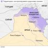
Geographical discoveries of the Middle Ages. Technological map of the geography lesson on the fgos topic: geographical discoveries of antiquity and the Middle Ages Where did you visit and when
Geographic discoveries of antiquity and the Middle Ages

1 . Why do people study the Earth? 2 . What geographical discoveries did people in antiquity?


- V Eastern Mediterranean lived amazing on genus - Phoenicians.
- They swam boldly mediterranean sea , went out to Atlantic Ocean . It is they discovered the Azores and Canary Islands.
- In the VI century. BC e. the Egyptian pharaoh Necho instructed them to study whether the country is great Libya (So called in ancient times Africa ). Nearly It took the Phoenicians three years to go around Africa. Travel show lo what Africa is very big and from all sides surrounded by seas.

The Phoenicians lived
on the east
coast
mediterranean sea,
where they created a series
trading cities
states from which
most famous
Tire and Sidon .


Great geographers of antiquity.
Herodotus(5th century BC)
Historian and traveler, who gave a description of many countries, the history and way of life of peoples.
He visited Scythia (southern part Russia ), where the ski tribes lived Fov and Sarmatians.
Described the climate Egypt , spill Nile .


Scythians - peoples who lived in the era of antiquity and the Middle Ages, both in Eastern Europe and in Asia. The ancient Greeks called the country where the Scythians lived - Scythia

Pytheas
In the IV century. BC e. ancient Greek scientist and navigator Pytheas leaving the mediterranean ya, he circled the shores Spain and France and reached Ireland and Great Britain .
Then he visited the lands Germans , rich amber.
Pytheas was the first to establish the relationship between geographic latitude and the length of day and night.

Travels of Pytheas
Pytheas
around 325 BC
traveled along the shores of Northern Europe, reached the shores of Ireland and Great Britain

Eratosthenes
Eratosthenes first used the term "geography".

Eratosthenes
ancient greek scientist Eratosthenes
in the II century. BC e.
measured the length of the equator and calculated
dimensions of the globe,
isolated for the first time on our planet
climatic zones
Map drawn by Eratosthenes

3 . Geographical discoveries of the Middle Ages
- In the Middle Ages, much was done for the development of geography Arab sailors.
- They mastered the waters indian ocean , founded their colonies on the coast East Africa, visited India and China.

- Traveled around Indian ocean, explored the coast Africa and Arabia.


- In 1721, he went with his family on a long trading journey to the East. Marco Polo spent a total of 22 years in his wanderings and, returning to his homeland, described what he saw in his book "On the Diversity of the World": climate features, customs of different countries, architecture of cities, their inhabitants.

- In 1487, an expedition led by Bartolomeo Dias (c. 1450-1500) reached the southernmost point of African mainland, which was named cape Storms . Later it
renamed to cape Good Hope, as this is a discovery by gave hope for the opening of a sea route to India.


- swim to India, rounding Africa, succeeded only in 1498. navigator
(c. 1469-1524).


Eratosthenes
- They circled Africa first.
- Traveler who visited Scythia (southern part of Russia).
- He was the first to establish the relationship between the length of day and night and latitude and longitude.
- Measured the length of the equator and calculated the size of the Earth
Herodotus
Pytheas
Phoenicians

- Been to India.
- The first to reach the southern point of Africa.
- He was the first to circumnavigate Africa from the south.
Marco Polo
Pytheas

Restore the original text by choosing the names suggested after the text.
Lost” names (given in alphabetical order): Herodotus, Marco Polo, Pytheas, Eratosthenes.
Eratosthenes
Geography is the science of the earth. The name of this science was given by the Greek scientist _________. The outstanding travelers were the ancient Greeks ___________ and _________, who in their travels collected interesting information about the peoples, described the nature of unknown countries. In 1271, through the Mediterranean Sea, along the valleys of the Tigris River to the Persian Gulf, through the deserts and mountains of Central Asia, _________ with his father and uncle laid a trade route to China. But the real time of geography was the era of the Great Geographical Discoveries (the end of the 15th - the beginning of the 17th century). Europeans were looking for a sea route to the rich countries of the East. Expedition _________ went in search of a waterway to India around Africa.
Herodotus
Pytheas
Marco Polo

- The Phoenicians were the first to circumnavigate Africa.
- Herodotus left descriptions of many countries
- Pytheas found his way to the British Isles.
- Eratosthenes gave the name to science - "geography", measured the circumference of the Earth.
- Arab navigators mastered the waters of the Indian Ocean, visited India and China.
- An amazing journey was made by the Venetian merchant Marco Polo.
- Bartolomeo Dias reached the southernmost point of Africa,
- Vasco da Gama sailed to India.

TEST YOUR KNOWLEDGE
1. What voyages did the Phoenician sailors make?
2. What is the merit of the ancient Greek scientist Eratosthenes?
3. What is the merit of Herodotus?
4. What discoveries did Pytheas make?
5. What journey did Marco Polo make7
6. Who was the first to reach the southern point of Africa?
7. How was Africa called in ancient times?
8 Which navigator was able to circumnavigate Africa and reach India.
TECHNOLOGICAL CARD LESSON №6
Lesson type : lesson "discovery of new knowledge"
"Geographical discoveries of antiquity and the Middle Ages"Target
Content (formation of a system of concepts) - introduce the history of geographical discoveries of antiquity and the Middle Ages.
Activity (formation of skills of new ways of action) - Ability to work with a contour map.
Tasks
Educational: form an idea of the development of geography through the history of geographical discoveries.
Developing: create conditions for the development of cognitive intereststo the subject.
Educational: the formation of a culture of communication in the classroom.
Planned results
Subject:
- the student will learn: call the main ways of studying the Earth in the past and at present;
call the most outstanding results of geographical discoveries and travels;show routes on the map;
- the student will have the opportunity to learn:
perceive and critically evaluate information of geographical content in popular science literature and the media.
Metasubject:
1) Regulatory: set learning objectives based on the correlation of what is already known and learned by students, and what is still unknown; compare the results obtained with the expected ones.
2) Cognitive:
Brain teaser: solve educational problematic tasks, systematize information, identify cause-and-effect relationships.
general educational : working with text and extra-text components: transferring information from one view to another (text to table).
Sign-symbolic: work with illustration, geographical maps.
3) Communicative: briefly formulate thoughts in written and oral form, development of skills of cooperation, tolerant attitude to other people's opinion, development of basic social roles and rules.
Personal: the formation of an emotional and value attitude to the topic under study, the realization of the practical and personal significance of the material being studied.
Basic concepts and terms
Personalities: Herodotus, Pytheas, Eratosthenes, Marco Polo, Bartolomeo Dias, Vasco da Gamma.
Intersubject communications
Geography, history, social studies.
Resources:
main
additional
PC, presentation, interactive whiteboard, handout, geography atlas Grade 5,electronic application, textbook “Geography. Beginning course. Authors: Barinova I.I., Pleshakov A.A., Sonin N.I.-M. : Bustard, 2014.
Lesson Form
Forms of learning activities: individual, group, frontal. Practical work №1.
Methods and techniques: conversation, teacher's story, independent work with a textbook, atlas, contour map
Technology
"Technology based on the creation of a learning situation".
The learning situation is the fulfillment of the task - practical work.
Didactic technological map
Lesson stagesBasic lesson content
(The activity of the teacher, its content, forms and methods)
Educational-cognitive and educational-practical tasks
The activity component of the lesson at the level of educational actions
(Activity of students, its content, forms and methods)
UUD
one . Self-determination to activity.
Motivational
Greeting students. Inclusion in the business rhythm. Checking everything you need for the lesson.
Includes music with song"Merry Wind":
Come on, sing a song to us, cheerful wind,
Cheerful wind, cheerful wind!
Seas and mountains you searched everything in the world
And I heard all the songs in the world.
Sing to us, wind, about wild mountains,
About the deep secrets of the seas.
About bird talk
About the blue spaces
About brave and big people!
No science is so rich in exciting adventures as geography. The novels of Jules Verne, Mine Reid, Alexandre Dumas pale before the real stories of great expeditions and discoveries. And how could it be otherwise, if this science was not created by armchair scientists who spent their whole lives within the walls of laboratories. Among the famous travelers you can find pirates and adventurers, bandits and scouts, brave and courageous scientists. Of course, many went on trips and expeditions, driven by the desire to see and know the Earth on which they live.
Interact with the teacher during the conversation. Get involved in activities.
Personal: learning motivation,
meaning formation (“what is the meaning, the meaning of the teaching for me”, and be able to find the answer to this question),
moral and ethical assessment.
Regulatory: volitional self-regulation as the ability to mobilize forces and energy.
2. Updating knowledge and fixing difficulties in activities
1. Why do people study the Earth?
2. What geographical discoveries did people make in antiquity?
The development of new lands continued for more than one millennium. People studied their planet together. The memory of this was preserved on the maps: many geographical objects are named after travelers, sailors, explorers, and scientists.
Many amazing discoveries have been made by people.
Formulate the topic of the lesson.
3. What would you like to know about the topic of the lesson?
4. What result do you expect?
They suggest how people gradually learned to explain natural phenomena based on experience and knowledge.
Come out with the help of a teacher on the topic "Geographical discoveries of antiquity and the Middle Ages ", write in a notebook.
Express their guesses.
Express their guesses.
Personal: formation of the boundaries of one's own knowledge and "ignorance".
Regulatory: set learning objectives based on the correlation of what is already known and learned by students, and what is not yet known.
Cognitive: general education - mastering the initial forms of cognitive reflection.
Communicative: briefly formulate thoughts orally.
3. Statement of the educational task, problem situation
1. What is the purpose of the lesson?
2. To achieve the goal of the lesson, you must:
Considerthe most important discoveries of antiquity and the Middle Ages;
Mark the routes of travelers of the Middle Ages on the contour map.
Determine the purpose of the lessonmeet tohistory of geographical discoveries of antiquity and the Middle Ages.
Tasks are named:
Explore
Define
Repeat
Compose…
Personal: education of culture in the classroom.
Regulatory: monitoring peer responses.
Cognitive: general education - goal setting, the ability to draw conclusions.
Communicative: development of a common solution, mutual assistance, expression of one's own opinion.
4. Building the project
getting out of trouble
situations of difficulty
The organization of students' activities, during which a new way of action is built and justified: the teacher, together with the students, determines how knowledge will be obtained.
Included in independent activities to create new knowledge.
Regulatory: planning - determining the sequence of intermediate goals, taking into account the final result; planning and
sequence of actions.
5. Implementation of the constructed project
(learning new material)
Organizes the activities of students to work with new information.
The "School of the Pathfinder Geographer" begins to work. Now we are setting off on a journey in the footsteps of travelers of antiquity and the Middle Ages.
To begin with, let's define the time frame of antiquity and the Middle Ages:
- Ancient world: from the beginning of the Bronze Age to the deposition of the last Roman emperor in 476 AD);
- Middle Ages: 476-1492 before the discovery of America.
Write in notebooks.
We work in pairs: choose a vehicle, determine the name of your expedition.
Using § 5 of the textbook, fill in the logbook (table): "The most important discoveries of antiquity and the Middle Ages."
Fizkultminutka.
Record the periods of antiquity and the Middle Ages.
Implementation of practical work No. 1.
Expedition name: _________________________
"The most important discoveries of antiquity and the Middle Ages"
"Discoveries of antiquity"
Using the text of the textbook §5, fill in the table:
swam?
Reasons for traveling?
What geographical knowledge was formed?
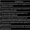
Using the text of the textbook §5, fill in the gaps in the table by selecting the necessary dates and facts from the proposed list:
1. ?
(B)
He described many countries, the history and life of peoples, the climate of Egypt, the floods of the Nile.
Ancient Greek scientist Pytheas
4th century BC.
(D)
Ancient Greek scholar Eratosthenes
3 ?
(V)
(E)
Marco Polo
1721
He described the features of the climate, the customs of different countries, their inhabitants, the architecture of cities,
Bartolomeo Dias
1487
(W)
Vasco da Gama
6. ?
(A)
7. ?
(G)
A. 1498D . Found my way to Ireland and the UK
B. 5th century BC.E . Measured the length of the equator, calculated the dimensions
V. 2nd century BC. the globe, singled out climatic
G. Sailed to India
around Africa. belt, created a map of the inhabited part of the Earth gave
the name of the science is geography.
J. Reached the southernmost point of Africa
which was named Cape Storms.
Write down the numbers from 1 to 7 in a column;
Next to the number, write the letter of the correct answer chosen from the list;
Write your answer in the appropriate box.
A)

B)

V)
HOW TO COMPLETE THE TASK?
Write down the letters from A to B
Next to the letter, write the name of the navigator whose route is shown in the figure.

Performing general impact exercises in accordance with SanPiN 2.4.2.2821-10
Personal: mutual assistance.
Regulatory: evaluation of objective difficulties, formulation of conclusions.
Cognitive: mastering the initial information about the essence and characteristics of objects, processes and phenomena of reality in accordance with the content of a particular academic subject.
Communicative:
Consciously build speech and
written statement;
Willingness to listen to the interlocutor and conduct a dialogue.
6. Primary consolidation of educational material
1. What voyages did the Phoenician sailors make?
2. What is the merit of the ancient Greek scientist Eratosthenes?
3. Can it be argued that only European peoples were engaged in the study of our planet?
Answer questions orally.
Regulatory: correction - making the necessary additions.
7. Independent work (primary skill test)
Organizes a test according to the standard of practical work.
The practical work is assessed by the teacher and compared with the student's assessment.
Using the individual form of work:
assessment of their independent work according to the algorithm:
1. What was the task? (Learning to remember the purpose of the task).
2. Were you able to complete the task? (Learning to compare the result with the goal).
3. The task is completed, right, or not quite? (Learning to find and admit mistakes).
4. Did you do it yourself or with someone else's help? (Learning to evaluate the process).
5. What mark would you give yourself? (Maximum 13 points:
6-9 points - "3";
10-12 points - "4";
13 points - "5".
"Discoveries of antiquity"From 1 point to 3 points
"The most important discoveries of the Middle Ages"
From 1 point to 7 points
"Traveler Routes"
From 1 point to 3 points
Regulatory : the ability to evaluate your work.
8. Incorporating new knowledge into the system
and repetition
(meaningful reflection)
Selects tasks in which the use of the studied material is trained.
Composethose SMS text on behalf of a Phoenician or traveler of the Middle Agesabout interesting sailing events.
1. Inclusion of new knowledge in the knowledge system.
Communicative: building productive interaction and cooperation.
Cognitive: independent construction of new learning goals, based on previously learned methods of action.
Personal: the formation of empathy, as a conscious understanding of the feelings of other people.
9. Reflection of activity (outcome of the lesson)
Reflection of the emotional state
Remember what goals we set at the beginning of the lesson? Have we reached them? Have we succeeded? What interesting things did you find out?
2. What actions did you take in the lesson to prove the following statement...
3. What sources of information did we use to find out (on the topic of the lesson)?
At the lesson I ... (+ or -)
2. I am satisfied with my work in a group (pair)3. There was no right job for me
4. Lesson for me seemed short
5. For the lesson I'm tired
6. My mood has improved
7. The material of the lesson was interesting to me
8. The material of the lesson was useful to me
9. I felt comfortable in class today.
Ι. Knowledge update.
* Mark students who correctly formulated the topic of the lesson.
ΙΙ. Discovery of new knowledge.
* Mark the students who worked well with the table.
ΙΙΙ. Application of new knowledge.
* Mark the students who answered the questions well, drew conclusions.
Students' responses.
Written reflection, in the lesson I:
Caravels are located on the wall map.
Regulatory: assessment - the selection and awareness by students of what has already been learned and what is still to be mastered, awareness of the quality and level of assimilation.
Communicative: ability to express one's
thoughts; formulate
own opinion and position.
Personal:
implementation of personal reflection when summing up.
10. Homework
1. Mandatory for everyone:
- §5, questions after §.
2.Optional (optional or optional):
A) Tasks electronic application and workbook;
B) Presentation (message) about the life of a traveler in the Middle Ages.
Determine the scope and content of homework related to the next stage of learning.
Write down d / z in the diary.
Regulatory : plan their actions in accordance with the task and the conditions for its implementation, including in the internal plan; take into account the established rules in planning and controlling the solution method;
carry out final and step-by-step control on the result.
LESSON PLAN
« Geographical discoveries of antiquity
and the Middle Ages».
Teacher: Menailenko Inga Konstantinovna
Place of work: Temryuk district, Akhtanizovskaya station, MBOU secondary school No. 10
Thing: geography.
Class: 5
Lesson topic No. 6: "Geographical discoveries of antiquity and the Middle Ages"
Basic Tutorial: I.I.Barinova, A.A.Pleshakov, N.I.Sonin
The purpose of the lesson: Introduce the history of geographical discoveries.
Tasks:
subject–
1. Reveal and know the history of geographical discoveries of antiquity and the Middle Ages
2. Know the names of the discoverers: Herodotus, Pytheas, Eratosthenes, Marco Polo, Bartolomeo Dias, Vasco da Gama.
metasubject– The ability to work with a map of the hemispheres, with contour maps, with the text of a textbook, to highlight the main thing in it.
personal– The manifestation of educational and cognitive interest in geographical science.
Lesson type- a lesson in the "discovery" of new knowledge.
Equipment: physical map of the hemispheres, electronic application
STRUCTURE AND PROCESS OF THE LESSON