Territory planning and surveying project - stages of development. Features of the territory surveying project Gradkodeks territory planning project
GOVERNMENT OF THE RUSSIAN FEDERATION
RESOLUTION
On approval of the Regulations on the composition and content of territory planning projects providing for the placement of one or more linear objects
Document with changes made:
(Official Internet portal of legal information www.pravo.gov.ru, 07/09/2019, N 0001201907090027).
____________________________________________________________________
In accordance with Part 5 of Article 42 of the Town Planning Code of the Russian Federation, the Government of the Russian Federation
decides:
1. Approve the attached Regulations on the composition and content of territory planning projects that provide for the placement of one or more linear objects.
2. The requirements for the composition and content of territory planning projects established by the Regulations approved by this resolution do not apply to territory planning projects, the decision to prepare which was made before the entry into force of this resolution.
Chairman of the Government
Russian Federation
D.Medvedev
Regulations on the composition and content of territory planning projects providing for the placement of one or more linear objects
APPROVED
Government resolution
Russian Federation
dated May 12, 2017 N 564
I. General provisions
1. These Regulations establish the composition and content of territory planning projects that provide for the placement of one or more linear objects (hereinafter referred to as the territory planning project).
2. Preparation of the territory planning project is carried out along the external boundaries of zones as far as possible from the planned route of linear objects (routes) with special conditions for the use of territories that are subject to establishment in connection with the placement of these linear objects.
3. Graphic materials included in the territory planning project are developed on a scale from 1:500 to 1:5000, unless a different scale is established by these Regulations in relation to individual graphic materials of the territory planning project.
4. Preparation of the graphic part of the territory planning project is carried out in accordance with the coordinate system used to maintain the Unified State Register of Real Estate.
5. It is not allowed to display information not provided for by these Regulations in the territory planning project, except when this is established by the task for the development of documentation for territory planning (hereinafter referred to as the task).
6. The territory planning project must meet the requirements established by the assignment.
II. Composition of the territory planning project
7. The territory planning project consists of the main part, which is subject to approval, and materials for its justification.
8. The main part of the territory planning project includes:
section 1 "Territory planning project. Graphic part";
Section 2 "Regulations on the placement of linear objects."
9. Materials to justify the territory planning project include:
Section 3 "Materials for substantiating the territory planning project. Graphic part";
Section 4 "Materials for substantiating the territory planning project. Explanatory note."
III. Contents of the main part of the territory planning project
10. Section 1 "Territory planning project. Graphic part" must be presented in the form of a drawing (drawings) made on a digital topographic plan that meets the requirements established by the federal executive body exercising the functions of developing and implementing state policy and legal regulation in the field of construction, architecture, urban planning.
11. Section 1 "Territory planning project. Graphic part" includes:
drawing of red lines;
drawing of the boundaries of the zones of the planned location of linear objects;
drawing of the boundaries of the zones of the planned location of linear objects that are subject to transfer (redevelopment) from the zones of the planned location of linear objects.
Combining several drawings into one is permitted provided that the lines and symbols of graphic materials are readable.
12. The red line drawing shows:
b) existing (previously established in accordance with the legislation of the Russian Federation), established and canceled red lines;
c) numbers of characteristic points of red lines, including points of beginning and end of red lines, points of change in the description of red lines. The list of coordinates of characteristic points of the red lines is given in the form of a table, which is an integral appendix to the drawing of the red lines;
d) explanatory notes containing information about the types of linear objects in relation to the territories that are occupied by such objects or intended for their location, about the types of public areas for which red lines have been established and (or) are being installed.
13. The drawing of the boundaries of the zones of the planned placement of linear objects shows:
a) the boundaries of the territory in respect of which the planning project is being prepared;
b) the boundaries of the zones of the planned location of linear objects, indicating the boundaries of the zones of the planned location of capital construction objects included in the linear objects, ensuring, among other things, compliance with the calculated indicators of the minimum permissible level of provision of the territory with objects of communal, transport, social infrastructure and the calculated indicators of the maximum permissible level of territorial accessibility of these objects for the population in accordance with urban planning standards. The locations of capital construction objects that are part of a linear facility are subject to clarification during architectural and construction design, but cannot go beyond the boundaries of the zones of the planned location of such objects established by the territory planning project. If the placement of linear objects requires the formation of land plots, the boundaries of the zones of the planned placement of linear objects are established in accordance with the norms for the allocation of land plots for specific types of linear objects;
by Decree of the Government of the Russian Federation of July 6, 2019 N 864.
c) numbers of characteristic points of the boundaries of the zones of the planned location of linear objects, including starting and ending points, points of change in the description of the boundaries of such zones;
d) boundaries of zones with special conditions for the use of territories to be established in connection with the placement of linear objects.
14. The drawing of the boundaries of the zones of the planned location of linear objects subject to transfer (reconstruction) from the zones of the planned location of linear objects shows:
a) the boundaries of the territory in respect of which the planning project is being prepared;
c) numbers of characteristic points of the boundaries of the zones of the planned location of linear objects that are subject to transfer (redevelopment) from the zones of the planned location of linear objects;
d) boundaries of zones with special conditions for the use of territories to be established in connection with the placement of linear objects subject to transfer (redevelopment) from the zones of the planned location of linear objects.
15. Section 2 “Regulations on the placement of linear objects” must contain the following information:
a) name, main characteristics (category, length, design capacity, throughput, cargo load, traffic intensity) and purpose of linear facilities planned for placement;
b) a list of constituent entities of the Russian Federation, a list of municipal districts, urban districts within the constituent entities of the Russian Federation, a list of settlements, settlements, intracity territories of cities of federal significance, on the territories of which zones for the planned location of linear objects are established;
c) a list of coordinates of characteristic points of the boundaries of the zones of the planned location of linear objects;
d) a list of coordinates of characteristic points of the boundaries of the zones of the planned location of linear objects that are subject to transfer (rearrangement) from the zones of the planned location of linear objects;
e) limit parameters of permitted construction, reconstruction of capital construction projects included in linear facilities within the boundaries of the zones of their planned location:
the maximum number of floors and (or) the maximum height of capital construction objects included in linear objects, within the boundaries of each zone of the planned location of such objects;
the maximum percentage of development of each zone of the planned placement of capital construction objects that are part of linear objects, defined as the ratio of the area of the planned location of a capital construction object that is part of a linear object, which can be built up, to the entire area of this zone;
minimum setbacks from the boundaries of land plots in order to determine the places of permissible placement of capital construction objects that are part of linear objects and outside of which the construction of such objects is prohibited, within the boundaries of each zone of the planned placement of capital construction objects that are part of linear objects;
requirements for architectural solutions for capital construction projects that are part of linear facilities, within the boundaries of each zone of the planned location of such facilities, located within the boundaries of the territory of a historical settlement of federal or regional significance, indicating:
requirements for the color scheme of the external appearance of such objects;
requirements for construction materials that determine the appearance of such objects;
requirements for volumetric-spatial, architectural-stylistic and other characteristics of such objects, affecting their appearance and (or) composition, as well as the silhouette of the building of a historical settlement;
f) information on the need to take measures to protect preserved capital construction objects (building, structure, structure, objects whose construction is not completed), existing and under construction at the time of preparation of the territory planning project, as well as capital construction objects planned for construction in accordance with previously approved documentation on the planning of the territory, from possible negative impacts in connection with the placement of linear objects;
g) information on the need to implement measures to preserve cultural heritage sites from possible negative impacts in connection with the placement of linear objects;
h) information on the need to implement environmental protection measures;
i) information on the need to implement measures to protect the territory from natural and man-made emergencies, including ensuring fire safety and civil defense.
16. The name of linear objects of federal, regional or local significance and their planned location, indicated in accordance with subparagraphs “a” and “b” of paragraph 15 of these Regulations, must correspond to the name and planned location established by territorial planning documents, except for cases when such linear objects are not subject to display in territorial planning documents. Discrepancies between information about the name and planned location (to the extent of the municipality) of linear objects of federal, regional or local significance contained in the territory planning project and information about the name and planned location of such linear objects contained in territorial planning documents are not allowed.
A change in the name of municipalities is not considered a discrepancy in information about the planned location of linear objects of federal, regional or local significance.
IV. Contents of materials to justify the territory planning project
17. Section 3 “Materials for the justification of the territory planning project. Graphic part” must be presented in the form of diagrams made on a digital topographic plan that meets the requirements established by the federal executive body exercising the functions of developing and implementing state policy and legal regulation in the field of construction, architecture, urban planning.
18. Section 3 “Materials for substantiating the territory planning project. Graphic part” contains the following diagrams:
a) layout of elements of the planning structure (territories occupied by linear objects and (or) intended for the placement of linear objects);
b) a scheme for the use of the territory during the preparation of the territory planning project;
c) a diagram of the organization of the road network and traffic flow;
d) diagram of the vertical layout of the territory, engineering preparation and engineering protection of the territory;
e) diagram of the boundaries of the territories of cultural heritage sites;
f) diagram of the boundaries of zones with special conditions for the use of territories;
g) a diagram of the boundaries of territories exposed to the risk of emergencies of a natural and man-made nature (fire, explosion, chemical, radioactive contamination, flooding, flooding, landslides, karsts, erosion, etc.);
h) diagram of constructive and planning solutions.
19. The arrangement of elements of the planning structure is developed on a scale from 1:10000 to 1:25000, provided that the lines and symbols of graphic materials are readable. This diagram shows:
a) the boundaries of the territory in respect of which the layout of elements of the planning structure is being prepared, within the boundaries of the subject (subjects) of the Russian Federation, on the territory of which the boundaries of the zones of the planned placement of linear objects and the boundaries of the zones of the planned placement of linear objects subject to transfer (reconstruction) from zones of planned location of linear objects;
(Subclause as amended, put into effect on July 17, 2019 by Decree of the Government of the Russian Federation dated July 6, 2019 N 864.
c) the boundaries of the zones of the planned location of linear objects that are subject to transfer (redevelopment) from the zones of the planned location of linear objects.
20. The diagram of the use of the territory during the preparation of the territory planning project shows:
a) the boundaries of the territory in respect of which the planning project is being prepared;
b) boundaries of the zones of the planned location of linear objects;
(Subclause as amended, put into effect on July 17, 2019 by Decree of the Government of the Russian Federation dated July 6, 2019 N 864.
d) information about the classification of land within the boundaries of the territory for which the planning project is being prepared to a certain category;
e) the boundaries of existing land plots registered in the Unified State Register of Real Estate, within the boundaries of the territory in respect of which the planning project is being prepared, indicating the numbers of characteristic points of the boundaries of such land plots, as well as the forms of ownership of such land plots and information about the need to withdraw such land plots plots for state and municipal needs;
f) the contours of existing preserved capital construction objects, as well as linear objects subject to demolition and (or) dismantling and not subject to transfer (rearrangement);
g) the boundaries of the zones of the planned placement of capital construction objects, established by previously approved documentation on the planning of the territory, in the case of the planned placement of such within the boundaries of the territory in respect of which the planning project is being prepared.
21. The scheme for organizing the road network and traffic flow is carried out in the case of preparing a territory planning project that provides for the placement of roads and (or) railway transport. This diagram shows:
a) the boundaries of the territory in respect of which the planning project is being prepared;
b) boundaries of the zones of the planned location of linear objects;
(Subclause as amended, put into effect on July 17, 2019 by Decree of the Government of the Russian Federation dated July 6, 2019 N 864.
c) the boundaries of the zones of the planned location of linear objects subject to transfer (redevelopment) from the zones of the planned location of linear objects;
e) lines of intra-block driveways and passages within the boundaries of public territory, boundaries of public easement zones;
f) stopping points of ground public passenger transport, entrances (exits) of underground public passenger transport;
g) transport infrastructure facilities, highlighting overpasses, overpasses, bridges, tunnels, off-street transport facilities, railway stations, passenger platforms, structures and devices for storing and servicing vehicles (including underground) and other similar facilities in accordance with regional and local urban planning standards;
h) utility passages and cattle passages, structures for the passage of wild animals;
i) main routes for pedestrian traffic, pedestrian crossings at the same and different levels;
j) directions of movement of ground public passenger transport;
k) other transport infrastructure facilities, taking into account the existing and forecast needs for transport support of the territory.
22. The scheme of vertical planning of the territory, engineering preparation and engineering protection of the territory is carried out in cases established by the federal executive body exercising the functions of developing and implementing state policy and legal regulation in the field of construction, architecture, and urban planning. Relevant information may be displayed on one or more diagrams, depending on the readability of lines and symbols. This diagram shows:
a) boundaries of the zones of the planned location of linear objects;
(Subclause as amended, put into effect on July 17, 2019 by Decree of the Government of the Russian Federation dated July 6, 2019 N 864.
b) the boundaries of the zones of the planned location of linear objects that are subject to transfer (reconstruction) from the zones of the planned location of linear objects;
c) existing and directive (design) surface marks along the axes of highways and railways, roadways at intersections of streets and driveways and at points of fracture of the longitudinal profile, as well as other planning elements for the vertical coordination of design solutions, including adjacent territories;
d) design longitudinal slopes, direction of the longitudinal slope, distance between points limiting the area with a longitudinal slope;
e) horizontal lines displaying the designed relief in the form of parallel lines;
f) transverse profiles of roads and railways, road networks on a scale of 1:100 - 1:200. The width of the road and functional elements of the transverse profile is given with an accuracy of 0.01 meters. Asymmetrical transverse profiles are accompanied by an explanatory inscription to orient the profile relative to the plan.
23. A diagram of the boundaries of territories of cultural heritage objects is developed in the case of the presence of cultural heritage objects within the boundaries of the territory in respect of which the planning project is being prepared. If there are no cultural heritage objects within the boundaries of the territory for which the planning project is being prepared, the relevant information is indicated in section 4 “Materials for justifying the territory planning project. Explanatory note”. This diagram shows:
a) the boundaries of the territory in respect of which the planning project is being prepared;
b) boundaries of the zones of the planned location of linear objects;
(Subclause as amended, put into effect on July 17, 2019 by Decree of the Government of the Russian Federation dated July 6, 2019 N 864.
c) the boundaries of the zones of the planned location of linear objects subject to transfer (redevelopment) from the zones of the planned location of linear objects;
d) the boundaries of the territories of cultural heritage objects included in the unified state register of cultural heritage objects (historical and cultural monuments) of the peoples of the Russian Federation;
e) boundaries of the territories of identified cultural heritage sites.
24. The diagram of the boundaries of zones with special conditions for the use of territories, which can be presented in the form of one or several diagrams for individual types of zones, displays:
a) the boundaries of the territory in respect of which the planning project is being prepared;
b) boundaries of the zones of the planned location of linear objects;
(Subclause as amended, put into effect on July 17, 2019 by Decree of the Government of the Russian Federation dated July 6, 2019 N 864.
c) the boundaries of the zones of the planned location of linear objects subject to transfer (redevelopment) from the zones of the planned location of linear objects;
d) boundaries of zones with special conditions for the use of territories approved in accordance with the established procedure:
boundaries of security zones of existing utility networks and structures;
boundaries of zones of existing protected and sensitive facilities;
boundaries of sanitary protection zones of water supply sources;
borders of coastal protective strips;
boundaries of water protection zones;
boundaries of protection zones for cultural heritage sites (historical and cultural monuments) of federal, regional and local significance;
boundaries of flood zones, flooding;
boundaries of sanitary protection zones of existing industrial facilities and production facilities and (or) their complexes;
boundaries of mineral deposit areas;
boundaries of protective zones of stationary observation points for the state of the environment and its pollution;
borders of the roadside strip of the highway;
borders of the airfield area;
boundaries of railway security zones;
boundaries of sanitary gaps established from existing railway lines and roads, as well as energy facilities;
boundaries of other zones with special conditions for the use of territories within the boundaries of the preparation of the territory planning project, established in accordance with the legislation of the Russian Federation.
25. The diagram of the boundaries of territories exposed to the risk of natural and man-made emergencies (fire, explosion, chemical, radioactive contamination, flooding, flooding, landslides, karsts, erosion, etc.) displays:
a) the boundaries of the territory in respect of which the planning project is being prepared;
b) boundaries of the zones of the planned location of linear objects;
(Subclause as amended, put into effect on July 17, 2019 by Decree of the Government of the Russian Federation dated July 6, 2019 N 864.
c) the boundaries of the zones of the planned location of linear objects subject to transfer (redevelopment) from the zones of the planned location of linear objects;
d) boundaries of territories exposed to the risk of emergencies of a natural and man-made nature (in accordance with the initial data, materials of territorial planning documents, and in their absence - in accordance with regulatory and technical documents).
26. The diagram of constructive and planning solutions, prepared in order to justify the boundaries of the zones of the planned location of linear objects, displays:
a) the boundaries of the territory in respect of which the planning project is being prepared;
b) boundaries of the zones of the planned location of linear objects;
(Subclause as amended, put into effect on July 17, 2019 by Decree of the Government of the Russian Federation dated July 6, 2019 N 864.
c) the axis of the planned linear object with the application of picketage and (or) kilometer marks;
d) constructive and planning solutions planned in relation to a linear object and (or) capital construction objects included in the linear object, to an extent sufficient to determine the zone of the planned location of the linear object.
27. The graphic part of the materials for justifying territory planning projects may include diagrams in graphic form to justify the placement of linear objects, if this is provided for in the assignment.
Combining several diagrams into one is permitted only if the lines and symbols of the graphic part of the materials supporting the substantiation of the territory planning project are readable.
28. Section 4 “Materials for substantiating the territory planning project. Explanatory note” contains:
a) a description of the natural and climatic conditions of the territory for which the territory planning project is being developed;
b) justification for determining the boundaries of the zones of the planned location of linear objects;
c) justification for determining the boundaries of the zones of the planned location of linear objects subject to transfer (redevelopment) from the zones of the planned location of linear objects;
d) justification for determining the maximum parameters for the development of the territory within the boundaries of the zones of the planned placement of capital construction projects that are part of linear objects;
e) a statement of intersections of the boundaries of the zones of the planned location of a linear object (objects) with preserved capital construction objects (building, structure, structure, object whose construction is not completed), existing and under construction at the time of preparation of the territory planning project;
f) a statement of intersections of the boundaries of the zones of the planned location of a linear object (objects) with capital construction objects, the construction of which is planned in accordance with previously approved documentation on the planning of the territory;
g) a statement of intersections of the boundaries of the zones of the planned location of a linear object (objects) with water bodies (including watercourses, ponds, swamps, etc.).
29. The mandatory appendix to section 4 “Materials for substantiating the territory planning project. Explanatory note” is:
a) materials and results of engineering surveys used in the preparation of the territory planning project, with the attachment of documents confirming the compliance of the persons who performed the engineering surveys with the requirements of Part 2 of Article 47 of the Town Planning Code of the Russian Federation;
b) program and assignment for conducting engineering surveys used in preparing the territory planning project;
c) initial data used in preparing the territory planning project;
d) decision on the preparation of documentation on the planning of the territory with an assignment attached.
Revision of the document taking into account
changes and additions prepared
JSC "Kodeks"
The composition of the territory planning project is determined by the Town Planning Code of the Russian Federation (Chapter 5, Article 42).
1. Preparation of a territory planning project is carried out to highlight the elements of the planning structure, establish the parameters of the planned development of the elements of the planning structure, zones of the planned location of objects of federal significance, objects of regional significance, objects of local significance.
(as amended by Federal Law dated March 20, 2011 N 41-FZ)
2. The territory planning project consists of the main part, which is subject to approval, and materials for its justification.
3. The main part of the territory planning project includes:
1) drawing or drawings of the territory layout, which displays:
a) red lines;
b) lines indicating roads, streets, passages, communication lines, engineering and transport infrastructure facilities, passages to public water bodies and their coastal strips;
(as amended by Federal Law dated July 19, 2011 N 246-FZ)
c) the boundaries of the zones of the planned placement of social, cultural and public utility facilities, and other capital construction projects;
d) boundaries of the zones of planned location of objects of federal significance, objects of regional significance, objects of local significance;
(Clause “d” was introduced by Federal Law No. 41-FZ of March 20, 2011)
2) provisions on the location of capital construction projects of federal, regional or local significance, as well as on the characteristics of the planned development of the territory, including the density and development parameters of the territory and the characteristics of the development of social, transport service and engineering support systems necessary for the development of the territory.
4. Materials to justify the territory planning project include materials in graphic form and an explanatory note.
5. Materials for substantiating the territory planning project in graphic form contain:
1) layout diagram of an element of the planning structure;
2) a scheme for the use of the territory during the preparation of the territory planning project;
3) a scheme for organizing the road network, which may include a scheme for the placement of parking lots (parking spaces), and a scheme for traffic flow in the corresponding territory;
(as amended by Federal Law dated April 21, 2011 N 69-FZ)
4) a diagram of the boundaries of the territories of cultural heritage sites;
5) a diagram of the boundaries of zones with special conditions for the use of territories;
6) diagram of vertical planning and engineering preparation of the territory;
7) other materials in graphic form to substantiate the provisions on the planning of the territory.
6. The explanatory note specified in part 4 of this article contains a description and justification of the provisions relating to:
1) determining the parameters of the planned construction of social, transport service and engineering support systems necessary for the development of the territory;
2) protecting the territory from natural and man-made emergencies, carrying out measures for civil defense and ensuring fire safety;
3) other issues of territory planning.
7. The composition and content of territorial planning projects, the preparation of which is carried out on the basis of territorial planning documents of the Russian Federation, are established by this Code and the regulatory legal acts of the Russian Federation adopted in accordance with it.
8. The composition and content of territorial planning projects, the preparation of which is carried out on the basis of territorial planning documents of a constituent entity of the Russian Federation, territorial planning documents of a municipal entity, are established by this Code, laws and other regulatory legal acts of a constituent entity of the Russian Federation.
9. The territory planning project is the basis for the development of territory surveying projects.
A land surveying project is a document necessary for planning a site. A plan must be prepared for areas that have been built up or are being prepared for development. The territories are located within the boundaries of the structure of planning significance.
A boundary plan is developed to determine the boundaries of changing land plots and newly formed ones.
The preparation of the project is regulated at the legislative level; the rules are enshrined in Article 43 of the Town Planning Code. Below is a sample plan.
Statement
It will not be enough to develop construction documentation; it is necessary to obtain permission to carry out the work indicated in the project. When the land surveying and planning project is approved, these two plans are agreed upon and certified as a single document. It contains planning for land surveying and site development. This happens when:
- the land plot is built up;
- Such documents were previously approved.
In other situations, the certification will be like two different documents. The approval procedure is regulated by town planning legislation and municipal acts.
Planning and land surveying
The process includes:
- research of submitted documents;
- getting results.
The verification is carried out regarding the compliance of the submitted documentation with legal standards. The approval of the planning plan is the responsibility of the municipality. There are several committees that participate in the approval:
- management of the area where construction work will be carried out;
- engineering support;
- landscaping;
- environmental safety;
- energy;
- protection of cultural and historical monuments;
- ensuring order.
When the papers are agreed upon, the plan is submitted to the city planning committee, which reviews them. One month is allotted for reviewing the document. If the planning program is approved, then the corresponding order is adopted. The approved project is posted on the municipality portal.
For approval, the following conditions must be met:
- documentation is provided in electronic and paper format;
- presence of the organization's seal and signature of the person responsible;
- The sheets are stitched and numbered.
Approval of the papers is entrusted to the head of the local administration at the location of the facility. To do this, you need to provide a statement written by the land owners or a decision of the committee responsible for preparing the plan. Reconciliation occurs through hearings.
 Survey project
 If errors are found in the project after its approval, the document itself does not change. A revised act is attached to it. If a negative decision is made regarding approval of the plan, the decision must be justified.
Development of technical specifications
The technical specifications must include:

Planning procedure
In addition to carrying out construction work, the boundary design will be used when the land is divided into smaller components, even if the cadastral value is not registered. A plan is required when:
- alienation from the general territory of an allotment that is endowed with encumbrances;
- determining the boundaries of use of parts of a site that is in common shared ownership.
In these cases, the execution of project documents is associated with the desire of the owner of the site. Legislative acts do not establish rules regarding their mandatory application, but with their help it is possible to increase the efficiency of land use.
The creation of project documents for land surveying and planning are interdependent, since they contain different information and when preparing one, it is necessary to create the other. For this reason, plans need to be agreed upon.
Composition of information
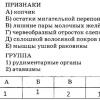
The information contained in the documentation is of a normative nature. The survey project includes cartographic and text parts. In the latter case, the main component is a table that contains a message of informational and descriptive value, giving the characteristics of the designed area, which includes:
- sections of the plan;
- resolutions of a basic and private nature;
- basic provisions.
 An example of planning and surveying of a real project
 Particular attention must be paid to drawing up the map. Its reproduction is carried out on paper. The base is the medium from which current information regarding the projected territory is copied.
According to established requirements, design information is applied to the cartographic base manually using blue ink. At the same time, the rules established for the preparation of such projects must be strictly observed.
Attention! the file cannot be used as a document. It is for informational purposes only.
Preparation requirements
The project is drawn up on the basis of the requirements prescribed by law. One of such acts is Order No. 388 adopted by the Ministry of Economic Development in 2011.
Provisions taken into account when drawing up the plan:
- use of Russian language;
- use of certain office supplies;
- rules that must be followed during transfer;
- numbering of sheets;
- points reflected in the project;
- map drawing rules;
- volume of text;
- use a sheet of paper in A4 format.
Order
You can order the preparation of a land surveying project from the municipal administration where the town planning committee is located. His powers include planning works of architectural significance, in particular the preparation of boundary plans. This body has the necessary license to carry out activities and is also equipped with specialists.
To prepare a boundary plan, you will need to get it approved, which requires the following documents:
- land cadastral passport;
- general plan sketch;
- topographic survey;
- area planning project.
detailed instructions
If the planning project is based on a land surveying plan, it is prepared in the same way. You must contact the municipal administration with an application. The project is prepared before or together with the preparation of the land survey plan.
When contacting the administration, the algorithm of actions is the same. Considering that the planning project acts as a baseline, it will initially be necessary to clarify whether it is possible to carry out construction work on the selected plot of land in accordance with the general plan.
You can submit an application only if the general plan allows construction.
The project in question has the same power as a construction permit. For this reason, the municipality pays great attention to its approval.
To receive a project, you need to collect a package of documents, which includes:
- topographic survey;
- assignment of architectural and planning type;
- town planning conclusion;
- documentation of title to the land;
- a certificate confirming connection to energy supply networks;
- technical specifications for design.
Other documents may be required by the competent authorities depending on the specifics of the plan. Coordination is carried out:
- chief architect;
- municipal administration;
- engineering services.
Linear object
The planning project for an object of linear significance consists of the main part that needs to be approved and materials to justify it. The main part includes provisions where data regarding the placement of linear objects is indicated. The substantive materials are presented in an explanatory note and a graphic part.
It reflects:
- route plan, which indicates the designation of transport networks, communication lines, power lines;
- boundaries of the territories within the boundaries of which the construction of a linear facility is planned.
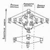
 Design and surveying of the territory of a linear facility
 The figure shows a project for the design and surveying of the territory on which the linear facility will be built.
How to make changes to the project?
It is necessary to make adjustments to the project if there are errors of technical or cadastral significance. These mistakes are made when carrying out land work or drawing up documents. If it is necessary to clarify some cadastral procedures, amendments and additions are also made.
If errors are discovered in the boundary plan, you must draw up a statement and submit it to the settlement administration. After approval, the plan does not change; a document containing the amendments is attached to it.
Cost and terms
In the case when a land surveying or planning project is prepared in the form of a separate document, the period depends on the area of the land plot. For example, when the land area is small, it can be developed within one month. If the boundary plan is formed together with the planning project, then the timing must be clarified with the developers.
The cost of producing plans is affected by the area of the site, as well as its location. The average cost is 60-70 thousand rubles. However, this value can vary both up and down.
Nuances
The nuances that may arise when drawing up planning and land surveying projects depend on the categories of land where construction is planned.
Special economic zone
When developing a plan, the parameters of the land plot, its location relative to the structure of the municipality are taken into account, and attention is also paid to the existing and planned environment. Based on the analysis of the specified data, the construction format is selected.
 Special economic parts of the Russian Federation
 Conditions to be met:
- connection with the environment;
- building density is low;
- placement in an area remote from the center or suburbs;
- availability of transport connections;
- the territory is landscaped;
- others.
The main task is to create an environment that will ensure the functioning of enterprises located in the SEZ, as well as a comfortable stay for employees of these organizations.
SNT plan
When surveying a land plot located on the territory of SNT, it is necessary to coordinate the procedure with the persons whose land is located next door, since their interests may be affected.
To obtain consent, you can hold a general meeting or contact each neighbor individually. An invitation to a meeting must be in writing. It is sent with notification of receipt.
In cases where it is not possible to contact a neighbor using a letter sent by post, you can place an ad in the newspaper.
Drawing up planning and land surveying is quite labor-intensive, and the preparation of these documents is mandatory. During collective construction, payment for the work is made from joint funds, which has a lesser impact on everyone’s budget than when there is only one participant.
The territory planning project and the land surveying project are two closely interrelated documents that allow the owner to realize his ideas in terms of construction, as well as some types of manipulations with the land.
Definition of the concepts of PPT and PMT
PMT - a territory surveying project - is a special documentation classified as urban planning, which is created taking into account certain types of activities that require land surveying within the site, in other words, if a common site must be divided into smaller ones, there is a need to formalize this project.
NOTE. It is not defined in cadastral records and differs from land surveying for the purpose of allocation. Information from the PMT is publicly available on the websites of municipal architectural departments (geodetic department).
PPT - a territory planning project - is also an urban planning document and is closely related to the land surveying project, but its content reflects in more detail the characteristics of the objects existing on the territory and their parameters, as well as the location zones of the planned construction projects.
Why are PPT and PMT needed?
These projects are used for:
- Preparation for construction work;
IMPORTANT. These documents can be used not only on empty land, but also on areas with established infrastructure.

These two documents are so mutually dependent that when creating one of them, the need to create the other follows.
Application of PMT and PPT
Since these documents are based on, they are used for lands that are in shared ownership, for example:
- for agricultural lands, since the total territory, put on one cadastral register under one number, allows division on the basis of PMT and PPT;
- to obtain permission to construct a linear facility;
- to register ownership of a share of a plot in the local area of an apartment building;
- for lands intended for individual housing construction.
Composition of the land surveying project
 The PMT begins with a title page with information about the contractor and information about its structure and content. It consists of a text part and drawings, as well as materials for justifying this project.
Text part
- Information about the area of land formed, as well as possible methods of their formation;
- Information on the area of land related to public property, including for reservation and (or) withdrawal for municipal or state needs;
- Type of permit for the use of the created land plots in accordance with the territory planning project.
Blueprints
- Boundaries of existing objects or only planned ones (if the land surveying project is carried out as part of the PPT);
- Red lines approved in the PPT. Intended to indicate existing or planned construction projects;
- Indentation lines from the red lines to determine the locations of permissible placement of buildings, structures, structures;
- Areas of influence of public easements.
Justification materials contain boundaries
- Zones with special conditions of use;
- Protected natural lands;
- Objects of cultural heritage;
- Existing land plots;
- Capital construction projects.
Preparation requirements
The requirements themselves are enshrined in law, in articles of the Town Planning Code of the Russian Federation. In general, we can highlight the following important points in the design of a territory surveying project:

Step-by-step instructions for preparing PMT and PPT:
There are two options for preparing these projects: contacting the administration or a commercial campaign. In general, the algorithm of stages will be the same for PPT and PMT, since these documents are closely interrelated.
Contacting the administration is possible if the local municipality can offer such services.
- An application is submitted to an authorized person.
- Attached are the following documents:
- certificate of ownership;
- a sketch of the general plan of the land (plus a communications diagram);
- cadastral extract for the plot;
- extract on the presence/absence of permanent buildings;
- topographic plan (with communications).
- Based on them, the preparation of the project begins, where attention is paid to:
- soil structure;
- architecture;
- environmental friendliness of work;
- technical support;
- development results.
- If the decision is positive, then a technical specification is drawn up and cadastral manipulations are carried out.
- PPT and PMT are being developed.
- The PMT is agreed upon with the electric grid and water utilities at public hearings.
Everything is done for free. Completion period: within two months.
Contacting a special company is necessary when the administration has refused an application for projects. Then an agreement is concluded with an architectural company. In this case, the list of documents is identical, only the sketch can be excluded from the General Development Plan. All other actions are similar to administrative ones.
The period can be one month, the cost depends on the scope of work and the contract.
Samples for reference
Here is one of the project sheets:

Here you can see the title page of the territory surveying project:

This is what the territory planning project looks like:

This is what the survey project drawing looks like:

These projects are not easy to obtain, but they are necessary. This makes it possible to realize the prospects of the owner of the site for further free use of the land and for large developments.
Territory planning and surveying projects- This is a type of urban planning documentation. They can be developed together, within the same project, or as separate documents. Let's look at how to develop projects through the local administration and with the help of third-party specialists.
Territory planning project and territory surveying project
In accordance with Art. 51 of the Town Planning Code, there are two types of territory planning documents. This is a planning project and a land surveying project. Their development can be carried out simultaneously, within the framework of one package of documents, or separately, depending on the goals.
Definition of concepts
A territory planning project (PPT) is a document that reflects the elements of the planning structure and their development, and identifies areas allocated for the construction of objects for various purposes. One of the most important goals of its preparation is planning the development of the territory, taking into account existing facilities.
The PMT territory surveying project) is a document that is being developed to establish the boundaries of individual areas. On the topographic plan, which is a mandatory part of the project, the boundaries of the plots of different rights holders are marked, and on the basis of this the territory is zoned.
Thanks to these documents, it becomes possible to identify areas that have different statuses and purposes. It can be:
- Public areas, for example, squares, parks, sidewalks, etc.
- Private lands allocated, for example, for construction, and in relation to plots that have several owners, it is possible to determine the share of each of them.
- Territories for municipal facilities (schools, hospitals, administrative buildings).
- Areas for linear structures, incl. municipal and federal purposes (roads, pipelines).
What is the difference between PMT and PPT
The main difference between these documents is the level of detail in the data. For example, a planning project is developed for large areas, for example, a city district. It establishes the boundaries of public lands, regardless of their category of use. Since no territory is absolutely static, it changes over time, so previously established boundaries may not correspond to the actual ones. Another option is that old borders interfere with the normal development of the territory. In this case, the planning project allows you to reasonably change these boundaries.
The survey project has a higher level of detail information. It sets boundaries not only for public areas. The plan identifies the boundaries of private properties, built-up areas, adjacent areas, and lands occupied by infrastructure facilities. Some information in both documents is the same. For example, boundaries of public lands, roads, or pipeline sites will appear on both documents. The main information that the PMT contains is data on boundary boundaries. Based on this document, the development is planned, since it is necessary to maintain indentations from the red lines.
When planning and surveying projects are required
Planning and surveying projects refer to urban planning documentation, on the basis of which development planning and the laying of linear structures take place. All situations when it is necessary to prepare PMT and PPT are indicated in Art. 11.3. Land Code:
- For agricultural land (SNT, dacha partnerships, etc.). Lands are allocated to the partnership as a common area, which is in shared ownership. The territory of SNT or DNT can appear on the cadastre as one independent unit. At the same time, the law allows the allocation of separate plots from SNT lands, which are registered under their own cadastral number. To carry out such a procedure, PPT and PMT are required. The first document displays transport lines, utilities and other general purpose facilities located on the lands of the partnership. The land surveying project will establish the boundaries of individual land plots. Similarly, land is registered for individual housing construction, for example, for the construction of a cottage village.
- If conditional crushing is necessary for a large area. Example: land allocated for multi-storey construction. Project documentation should be not only for the building itself, but also for the design and improvement of the surrounding area.
- Establishment of easement. Since the easement is an encumbrance on the owner of the site, it must be allocated and registered. This is done on the basis of a land surveying project.
Preparing documents step by step
 There are two ways to prepare planning and surveying projects - through the local administration or by a third-party contractor.
If the municipality provides a similar service, it is simpler and easier to contact them. But here too there is a nuance. Local authorities may refuse development based on local acts. And this will be a completely legal basis for refusal.
Since, in general, the stages of the procedure are practically the same, in most cases, engaging a contractor is a more appropriate solution.
Step 1
First, you need to receive technical specifications for the preparation of documents. This can be done at the urban planning department. The application is also submitted there. As a rule, the stage passes quickly and without serious difficulties. When projects are developed by a third-party organization, both the applicant and the contractor can agree on the terms of reference. As a rule, this procedure is entrusted to the contractor company.
Step 2
The application and package of documents are handed over to an authorized person. This could be either the head of the local administration, for example, in small settlements, or an employee of the Urban Planning Committee. If possible, you should collect documents in advance. The package includes title documents, a General Plan sketch, a communications diagram, a cadastral extract, and a topographic plan. Sometimes the contents of the package may change, for example you will be asked to provide additional documentation.
Step 3
The preparatory stage, during which specialists from the Urban Planning Department analyze the documents submitted by the applicant and other data available to the administration in open sources. At the same time, during the preparation, the specialist considers the territory in context. That is, data on the soil, architectural objects, and ecological condition in the area are also taken into account. And the result of this approach is a decision on the possibility of construction on this site. If a positive decision is made, you can proceed to the next stage.
Step 4
At this stage, based on the terms of reference, specialists develop projects. A topographic plan is prepared on a cartographic basis, indicating the external boundaries of the surveyed area. For example, if the development of documents is needed to prepare for the construction of a multi-story building, the external boundaries of the land planned for development will be, including not only the area under the house, but also the surrounding areas. Internal boundaries, linear objects, etc. are drawn inside. The diagrams are supplemented with a textual descriptive part.
Step 5
After preparation, the documents must be approved at public hearings. In addition, the document will need to be coordinated with city services - electrical networks, water utilities, and gas services.
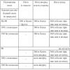
Time frames for preparation of PMT and PPT projects
 The time frame for preparing planning and land surveying projects ranges from 4 months, regardless of whether you act through the administration or contact third-party specialists. They are influenced by various factors, including those that neither you nor the contractor can influence, since they are determined by law. At Geomer Group, deadlines for completion are specified in the contract, and you will know in advance when our specialists will develop the documents.
Cost of development of PMT and PPT
When developing projects through the administration, the service is free for the applicant. All costs are borne by the municipality. But if the administration does not have the funds, prepare for refusal.
When the applicant engages a third-party company, he bears all costs himself. The cost depends on the purpose of document preparation. It is possible to accurately answer the question about prices only after analyzing the specific situation, its goals and objectives.